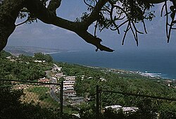
Saint John, Barbados
Appearance
Saint John | |
|---|---|
 | |
 Map of Barbados showing the Saint John parish | |
| Coordinates: 13°10′N 59°29′W / 13.167°N 59.483°W | |
| Country | Barbados |
| Government | |
| • Type | Parliamentary democracy |
| • Parliamentary seats | 1 |
| Area | |
• Total | 34 km2 (13 sq mi) |
| Population (2010 census) | |
• Total | 8,963 |
| • Density | 260/km2 (680/sq mi) |
| ISO 3166 code | BB-05[1] |
The parish of Saint John (St. John) is a parish of Barbados on the eastern side of the island. It is home to one of its secondary schools, The Lodge School and to the St. John's Parish Church.[2] In its southeastern corner the shoreline turns northward, forming the small Conset Bay.[3]
Geography
[edit]Populated places
[edit]
The parish contains the following towns, villages, localities, settlements, communities, and hamlets:
- Ashford Plantation
- Bath
- Bowmanston
- Cherry Grove
- Church View
- Cliff Cottage
- Cliff Plantation
- Clifton Hall
- Coach Hill
- Conset Bay
- Eastmont
- Edge Cliff
- Edey Village
- Foster Hall
- Four Roads
- Gall Hill
- Glebe Land
- Glenburnie
- Guinea
- Haynes Hill
- Hill View
- Hothersal
- Kendal
- Kendal Plantation
- Lemon Arbour
- Malvern
- Massiah Street
- Moores
- Mount Pleasant
- Mount Tabor
- Newcastle
- Palmers
- Pool
- Pool Plantation
- Pothouse
- Quintyne
- Rosegate
- St Margarets
- St Marks
- Sargeant Street
- Sealy Hall
- Sherbourne
- Small Hope
- Small Town
- Society
- Society Plantation
- Spooners
- Stewart Hill
- Venture
- Wakefield Plantation
- Welchtown
- Wilson Hill
Parishes bordering Saint John
[edit]- Saint George (west)
- Saint Joseph (north)
- Saint Philip (southeast)
Notable people
[edit]- Sarah Kirnon, chef[4]
References
[edit]- ^ iso:code:3166:BB, International Organization for Standardization
- ^ "Historic Churches of Barbados - St.John Parish Church". Retrieved 8 June 2016.
- ^ Plotting location as given by this map onto this image
- ^ "Barbadian chef serving up Caribbean cuisine in California". Loop News. 30 August 2017. Retrieved 3 January 2021.
External links
[edit] Media related to Saint John, Barbados at Wikimedia Commons
 Saint John travel guide from Wikivoyage
